17.33.020 Definitions.
The following terms used in this chapter shall have the meanings set forth in this section.
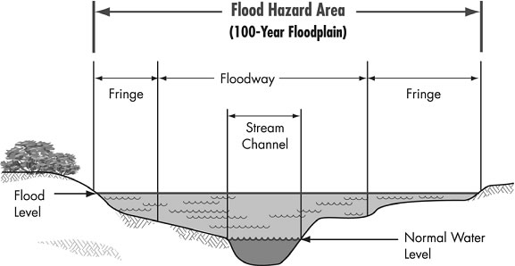
“Flood hazard areas” identified on the Flood Insurance Rate Map are identified as a Special Flood Hazard Areas (SFHA). SFHA are defined as the area that will be inundated by the flood event having a one percent chance of being equaled or exceeded in any given year. The one percent annual chance flood is also referred to as the base flood or one-hundred-year flood.
“Floodplain” means an area of nearly flat low-lying ground along the course of a stream, river, or coast that is naturally subject to flooding.
“Floodway” means the channel of a river or other watercourse and the adjacent land areas that must be reserved in order to discharge the base flood without cumulatively increasing the water surface elevation more than a designated height.
“Flood zones” are geographic areas that FEMA has defined according to varying levels of flood risk. These zones are depicted on a community’s Flood Insurance Rate Map (FIRM) or Flood Hazard Boundary Map and each zone reflects the severity or type of flooding in the specific area. (Ord. 15-05 (part), 2015)